
Nazis in Space and Other Tall Tales
Historical Economics Is Sometimes Just Noise

Nico Voigtländer and Hans-Joachim Voth’s recent article “Highway to Hitler” (2026) illustrates how space continues to be a major problem for historical economics. Published in American Economic Journal: Applied Economics, the article claims to show that building the Autobahn won Hitler votes. Across more than 3,000 German towns and cities, they report, “support for the Nazi regime increased significantly more in areas where the new motorways were being built”: the closer a town stood to a motorway under construction, the more its vote for the regime rose between the national votes of November 1933 and August 1934 (p. 134).
This finding only seems statistically significant, however, due to a novel approach to the problem of spatial dependence.
Simply put, the risk is that everything in Voigtländer and Voth’s regressions is a map, and almost everything measured across a map is smooth. Towns are the units of observation, but they often resemble their neighbors. As a result, 3,000 towns are not necessarily 3,000 independent pieces of evidence. They can be more like repeated measurements of a far smaller number of regions. Any regression that treats them as independent could therefore understate the actual uncertainty in its results.
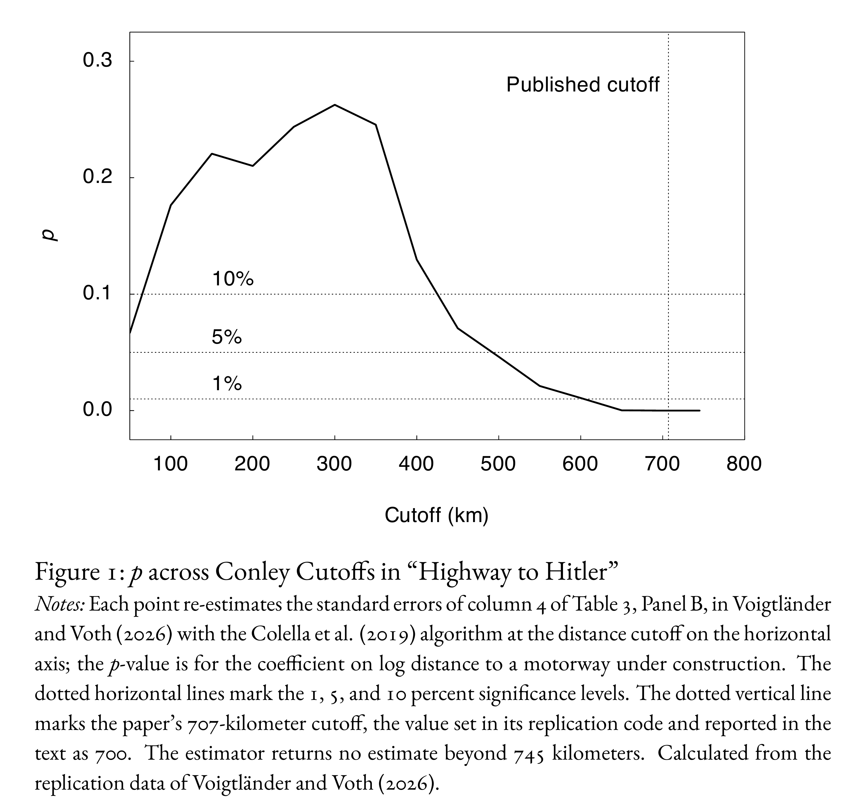
In 1999, Timothy Conley showed how to correct the standard errors to better reflect this uncertainty. Within a chosen radius, observations’ errors are allowed to move together; beyond it, they are treated as independent. The researcher should pick the radius to match the data: a distance beyond which the errors’ correlation is negligible. In the case of the main result in “Highway to Hitler,” Voigtländer and Voth choose a radius of 700 kilometers and provide an odd justification: “The cutoff of 700 km reflects the average distance of the most important east-west (Berlin-Aachen) and north-south (Hamburg-Munich) highway connections planned by the Nazi regime.” Rather than set the radius based on the observed spatial correlation, then, they set it to how long the roads were: 707 kilometers, to be precise. And they do so for no apparent reason.
This choice of a 707 kilometer radius generates the statistical significance of their result. Figure 1 shows how p > 0.10 from 150 to 400 kilometers and only becomes the < 0.001 Voigtländer and Voth report from ~650 kilometers. The cynically inclined might therefore conclude that the length of the roads was a post hoc story that is used to justify a nonsensical methodological choice that is needed for the effect to appear statistically different from zero.1
Some cautions could therefore be warranted regarding Voth’s recent claims about how the issues of spatial dependence in historical economics have been exaggerated. Specifically, he has defended at length one of his and Voigtländer’s articles on Nazism. In fact, as I will show here, both this article and Voth’s work on Nazism more generally have major problems, often related to space.
